01/08/17 Choranche- Col de la Cayolle (D route/ National Road/ Mountain D road) 10 am/ 7.30 pm
Finally we had a good night of sleep as the mattresses didn’t deflate at all.. We woke up quite early (8 am) compared to the previous days. We were a bit behind from what I planned and we had to catch up.. So after our usual hour and a half to pack and load we were ready to go. ( We went to the extreme of timing the setting up/packing and loading time to see if we’d improve… conclusion, no improvement)
We left little Choranche with the same feeling like when we left many other places; that we will be back there for a few days in the future!! We stopped for breakfast not far, in a little picturesque town called Pont en Royans where we spent a bit of time taking pictures of its beauty and of course, breakfast. ( a couple croissants with a cafe creme for Marie and a sausage roll, a pain au chocolat and two oranginas started to be our routine in the morning).

arriving in Pont en Royans

…literally built in between two rocks..

It is impossible to not stop for a couple pics..

the clock tower

… and beautiful everywhere!!!

Picturesque and old!!!

This seems what used to be a foot path..

Right, thought we stopped here for breakfast only!! 🙂
Our plan to catch up with the lost time was starting to fail as we always seemed to “waste” time here and there; if not taking pictures around, it would be someone local we would chat with or catching up with the occasional biker. Anyhow it just seemed that time was always flying without our due attention!
From Pont en Royans, we went to another amazing place (unfortunately we didn’t stop so I have no media thanks to my stupid Go Pro not recording properly).
The Petits Goulets followed by the Grands Goulets; they start from Sainte Eulalie en Royans to Saint Martin en Vercors on the D518. The Petits Goulets is a nicely shaped, narrow, and curvy road formed by 5 small tunnels dug in the rock. The beauty of it is that the tunnels are short and as you come out from one you get into the next one. After the Petits Goulets the road starts to go up with some inclination but always very curvy and with a few hairpins for 7 or 8 km until you reach a tunnel about 1,7km long. That’s the Grands Goulets tunnel. Unfortunately it is not possible to visit the original Grands Goulets as it is very dangerous due to rock falls and unstable terrain, so they are permanently closed to any person or vehicle, being the tunnel an alternative to it. Nothing special, but of course we did it as Marie loves tunnels.
⇓ ROUTE BELOW⇓
Back to Sainte Eulalie en Royans from the Goulets our route included another place quite picturesque but we needed a petrol station first, which wasn’t easy to find. We had to ride around 20 km to find one. Luckily the tanks weren’t that empty or we would be in trouble. In the Vercors Massif, no matter where you go, the scenery around is amazing, even from the petrol station close to Saint Jean en Royans.
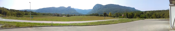
- I believe the Goulets are located somewhere in those mountains..
The Awesome Combe Laval
Le Cirque du Combe Laval is a balcony dangerous road frequently recognized as the most magnificent road in the French Alps. This infamous road was constructed between 1893 and 1896 and originally served for the transportation of timber from the Forêt de Lente to St. Jean en Royans. It is tightly hairpinned, with sharp and blind curves over the mountains. The road includes some steep sections, without marked central lines, is very narrow, barely wide enough for 2 cars at the same time and it has not protections or guardrails, however it is asphalted and kept in good condition. Pictures speak for themselves but still, they don’t make any justice to the beauty of the place. (I am sure I said this before).

The magnificent…

1893/1896

Erika and Matilda.. the warriors

the first sight..

the approach…

Unique

Fabulous

and amazingly dangerous

As it is common in the area.. roads and tunnels carved in the cliffs

Balcony roads, love them

A road not for the faint hearted

this picture is the perfect definition for balcony road, dangerous road, scenic road. Stunning!!!

… this is Combe Laval

Stunning views..

.. brutal

Easy to understand now the reason of my smile?
Wish we had more time to explore as I am sure that there are a lot of foot paths to enjoy but we had to keep moving. After this amazing balcony road we passed Col de la Machine which is a mountain pass at an elevation of 1.011m above the sea level, located near the tip of the remote Combe Laval in the Vercors massif, followed by the ski station de Font d’Urle. It is very scenic all over and the road simply spectacular in a way that you actually use the whole tyre surface in order to deal with the bends and hairpins leading us to a junction with a cemetery war memorial on the side…

not sure if WW1 or WW2..

respect!!

Right turn, Die via Col du Rousset here we go
As you can see loads to visit and to do.. next time hopefully!! We headed on towards Col du Rousset. The road views kept us entertained and busy but not as curvy or scenic as Combe Laval and the amazing gorges. We stopped by Col du Rousset ski station, this time to go on the ski lift which took us from 1250 meters to 1700 meters above the sea level. It’s pretty and scenic but probably more interesting during the winter season. After the cable descent we were both thirsty and feeling hot so we went to the ”Le rustic”, the only restaurant in the area. It was busy and the service was very poor ( maybe they were lacking staff), fact is that we waited for 25 to 30 min to be served a coke and no waiter/waitress ever approached, so we left without having a drink. (Hopefully you will be luckier.)

Col du Rousset ski Station


I was a bit anxious and Marie probably slightly concerned about what was coming next, the descent from Col du Rousset to Die. It´s a serpentine road in very good condition (D518), quite wide in most sections but its 14 tight hairpins along 9 miles ending in Chamaloc makes it either a paradise for the experienced biker and the nightmare for the less experienced. At this stage and after the long tunnel I “radioed” Marie to not follow me and keep her pace while I went frantically down the mountain eating hairpin after hairpin only to stop at the bottom, but always amazed by the scenery around. That felt good!! While waiting for Marie to arrive I met two other bikers who were hanging around next to their bikes to find out that Col du Rousset road actually attracts hundreds of bikers from everywhere due to the nature of the road, specially during Summer time. There´s also a biker camping somewhere not far where they gather. It was still very hot and definitely we were quite in need of a drink so, 30 min after we left the ski station we stopped again, this time for that coke we didn´t have at “Le Rustic“.

Col du Rousset tunnel

One of the 14 Hairpins

D518 near Chamalot

Chamalot
From here, we simply followed the D518 to Die which marked the end of our passage through the Massif de Vercors as we started the D93 national road heading towards Gap. Although the scenery around was pretty, we were running out of time to reach our destination for that day ( Savines-le-Lac), so we simply decided to keep on rolling without stopping. Following the map on my tank bag I previously marked, the national road between Die and Gap is not as curvy as the ones we were previously but still, pretty fun to ride only downsided by the fact that it´s busier but not that corwded, and there are a few speeding cameras here and there. (normally there are speeding cameras warning signs in order to get drivers aware of them, but it is something you have to keep an eye for, as they aren´t as visible as in the Uk). As we approached Gap it marked the end of the Drome region for us and a step in the Haute-Alps region.

Speeding cameras approach warning traffic sign

French speeding camera

Somewhere after Gap with a viewing of the Haute Alps

Marie looking at the Haute Alps and the dark grey sky on the right..
Something I learnt from my previous road trips, avoid cities as much as you can, otherwise it might be a pain to find the right way out due to their junction and intersections complexity. Yet, I did the same mistake and we ended up entering Gap. Fortunately it isn´t a big city, so after 30 mins around and confused we found the right way after refilling the tanks. Also we had to make a decision as it was nearly 5.30pm; to follow my plan and head to Savines-le-Lac for the night or, as we were a bit behind, skip it and push a bit further to the Col de la Cayolle. ( A mountain pass at 2300mts above the sea level, situated in between the department of the Alpes-de-Haute-Provence and the Alpes-Maritimes).
After a quick online research for accomodation and out of Gap we opted to go to the Col de la Cayolle via Barcelonnette. The D900/D902 would be our friendly roads for the next upcoming couple hours. As we passed Barcelonnette, we did a right turn off the national road (D900) to go up mountain, again on a narrow and twisty road (D902) (but not as dangerous and fantastic as the Vercors balcony roads). We could see a dark grey sky in the horizon over the mountains and we were riding towards it, we knew that definitely there would be rain included. The scenery was great as usual together with the occasional hairpin, bridge over the river and us surrounded by green fields and mountains making it an overall pleasant ride despsite the fact that D902 section not being well maintained as the roads we were used to. Bumpy with a few potholes, curvy, narrow and quite steep together with some light but constant rain.. Definitely not a good enviroment for two Honda CBR 600. After the Col on the other side and as we started the descent (D902 changes to D2202), the road wasn´t as in bad condition as before and the weather improved a bit… still very cloudy but not raining anymore even if the road was quite wet still.
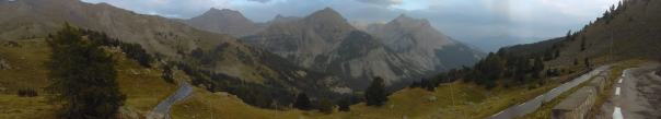

some of the great peaks

The descent on those amazing narrow twisted wet roads

what came after the hairpin.. Stunning!!!

Wet and a tricky hairpin
It was nearly 7.30Pm and as I mentioned before, you don´t want to ride for long after this hour or you may not find a place to stay overnight easily. So a few miles next to the top of the Col de la Cayolle we found a mountain refuge; “Refuge de la Cantonniere”. After checking prices and availability we decided to stay. It is a cosy mountain refuge, rustic and old fashioned without the usual gadgets you find at the typical B&B ( no TV and far from being a 5 star hotel). There was a few people staying over playing some kind of board games and the owner was quite warm and friendly. She served us an improvised meal as they weren´t expecting no one else, to which we were quite thankful for their hospitality. It was time then to relax over a beer and study the route for next day. We pushed a bit but we managed to catch up with the time loss en route. A nice hot shower and a comfortable bed after the beer as we were both a bit tired. At least we didn´t have to unpack and mount the tent on that night!!
